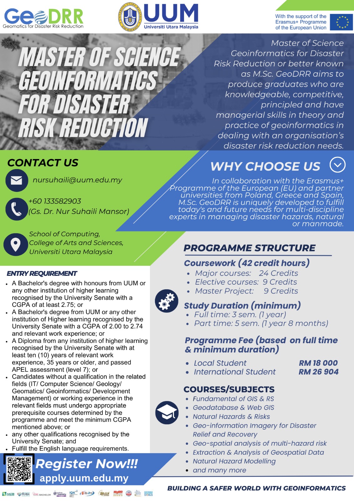
MASTER OF SCIENCE (GEOINFORMATICS FOR DISASTER RISK REDUCTION)
PROGRAMME DESCRIPTION
PROGRAMME AIM
M.Sc. GeoDRR is to produce graduates who are knowledgeable, competitive, principled and have managerial skills in theory and practice of geoinformatics in dealing with an organisation’s disaster risk reduction needs.
PROGRAMME LEARNING OUTCOMES
The programme learning outcomes of this programme are:
- Elaborate current knowledge in geoinformatics technologies and techniques for disaster risk reduction.
- Demonstrate creative and critical analysis skills, and propose innovative solutions.
Apply practical skills in planning, designing, developing, implementing, and evaluating geomatics technologies. - Build network and collaboration with stakeholders with positive attitudes professionally.
- Demonstrate a variety of effective communication methods in coordinating all geoinformatics activities for projects and research related to disaster risk reduction.
- Apply digital skill and knowledge in research career advancement activities of emerging information and communication technologies of geoinformatics for disaster risk reduction.
- Integrate and synthesize disaster management and geoinformatics for disaster risk reduction-related issues, and propose potential solutions using critically advanced quantitative and scientific approaches.
- Demonstrate excellent leadership capabilities in managing geoinformatics technology for projects and research related to disaster risk reduction.
- Demonstrate the capabilities and dispositions as Geoinformatics practitioners.
- Initiate managerial and entrepreneurial skills from Geoinformatics for disaster risk reduction applications.
- Demonstrate ethics and professionalism in geoinformatics for disaster risk reduction towards organizations.
General Requirement
- Bachelor's Degree with Honours from Universiti Utara Malaysia or any institution of higher learning recognized by the University Senate with a CGPA of at least 2.75; Or
- Bachelor's Degree from Universiti Utara Malaysia or any institution of higher learning recognized by the University Senate with a CGPA of 2.00 to 2.74 and related work experience; Or
- Diploma from any institution of higher education recognized by the University and passing the APEL test (rank 7); Or
- Senate with at least ten (10) years of relevant work experience, aged 35 years or older and passing the APEL examination (rank 7); or
- Any other equivalent qualification recognized by the University Senate; And
- Fulfil the English Language requirements as set by the University Senate.
International students need to meet one of the English Language requirements set by the University before they are accepted for admission.
- Students need to obtain:
- 550 in the TOEFL written exam; or
- 80 in the TOEFL website; or - Scored no less than 6.0 in the IELTS test; Or
- Obtain a bachelor's degree from any country whose language of instruction is English (i.e. Anguilla, Antigua and Barbuda, Australia, Bahamas, Barbados, Bermuda, Botswana, British Indian Ocean Territory, British Virgin Islands, Cameroon, Canada, Cayman Island, Dominica, Falkland Islands, Federated States of Micronesia, Fiji, Gambia, Ghana, Gibraltar, Grenada, Guam, Guernsey, Guyana, India, Ireland, Isle of Man, Jamaica, Jersey, Kenya Kiribati, Lesotho, Liberia, Madagascar, Malta, Marshall Islands, Mauritius, Montserrat, Namibia, Nauru, New Zealand, Nigeria, Pakistan, Palau, Papua New Guinea, Philippines, Rwanda, Saint Helena, Saint Kitts &; Nevis, Saint Lucia, Saint Vincent and the Grenadines, Samoa, Seychelles, Sierra Leone, Singapore, Solomon Islands, South Georgia and South Sandwich Islands, Sri Lanka, Sudan, Swaziland, Tanzania, Trinidad & Tobago, Turks and Caicos Islands, United States Virgin Islands, Uganda, United Kingdom, United States, Zambia and Zimbabwe) ; or
- Degree from any Public University in Malaysia with English as the medium of instruction; Or
- A degree from any Private University or University College in Malaysia listed in the Malaysian Qualifications Register (MQR).
If students do not meet any of the requirements of a Bachelor of Computing and Geomatics degree or do not have work experience in related fields recognized by the UUM Senate, they must take two (2) designated prerequisite courses namely STIA1113 Programming 1 and STIN1013 Introduction to Artificial Intelligence and must pass before they are allowed to register for the postgraduate program.
If students do not meet any of the above English Language requirements, they should attend English Courses for International Students offered at UUM for at least one semester and obtain a passing grade before they are allowed to enrol for a postgraduate program.
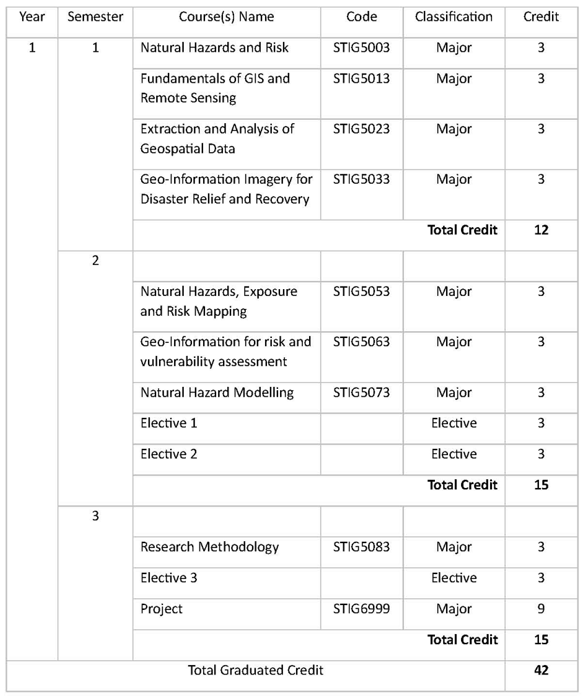
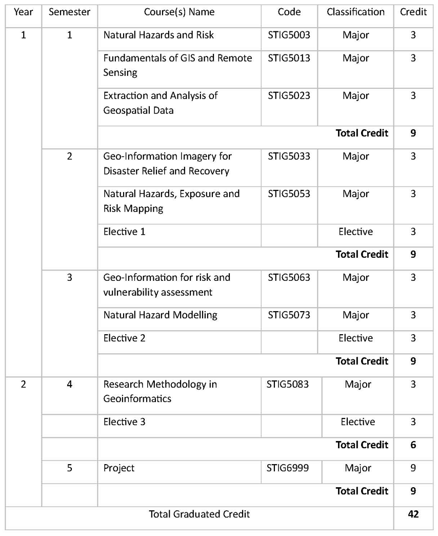
The Master of Science Geoinformatics for Disaster Risk Reduction programme by coursework is a 42-credit-hour programme which comprises the following courses:
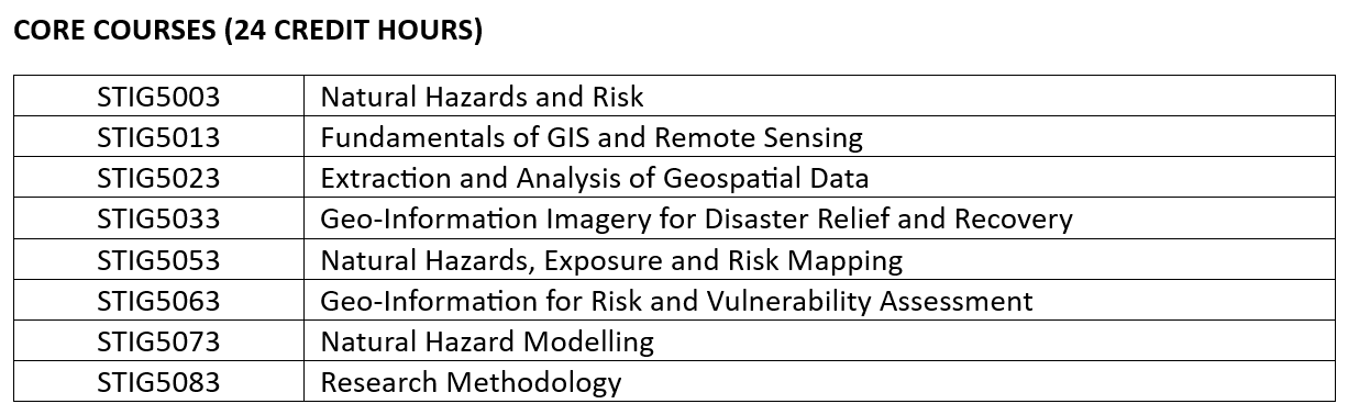

Core Courses M.Sc. GeoDRR
- STIG 5003 Natural Hazards and Risks
This course describes the state-of-the-art knowledge on natural hazard and the associated risks to assess the effects and impacts towards society. - STIG 5013 Fundamental of GIS and Remote Sensing
This course describes the latest knowledge on the basic concepts and analysis used in spatial data management involving Geographic Information Systems (GIS) and Remote Sensing (RS) and the solution of complex issues across multidisciplinary of geophysical fields and societal needs for disaster applications. - STIG 5023 Extraction and Analysis of Geospatial Data
This course focuses on using the pre-processed geospatial data for actual extraction and analysis of information. Basic geospatial principles for feature extraction are introduced using extracting online geospatial data (google map, google earth etc) and extracting from imagery. To analysis the geospatial data, the students also learn about multivariate and geostatistical analysis, network analysis, point pattern analysis, surface analysis, image interpretation analysis, analysis using computer programming language (among R, Python, C++ etc) and spatial modeling analysis methods, and more options for storing data effectively and efficiently using specially adopted database structure. Lastly, the students will have a good overview of acquisition and exploration of geospatial data principles and methods and be able to select the most appropriate data acquisition and exploration methods as well as working environment. - STIG 5033 Geo-Information Imagery for Disaster Relief and Recovery
The course focusing on Geo-Information Imagery data and applications including Global Navigation Satellite System (GNSS), Landsat TM, LIDAR, Microwave, Hyperspectral, Digital Elevation Model (DEM), Unmanned Aerial System (UAS), Geographic object-based image analysis (GEOBIA), Change Detection, Machine Learning and classification of remotely sensed data and geo-information data analytic. This course assumes that students have prior knowledge in the basics of Geo-Information Imagery and have experience with geospatial software, particularly ArcGIS. Upon completion students will be able to develop analytical workflows to derive products from Geo-Information Imagery for a broad range of applications. The culmination of this course is an independent final project in which students will demonstrate their ability to apply new skills to a real-world situation of personal or professional interest. - STIG 5053 Natural Hazards, Exposure and Risk Mapping
The course begins by reviewing key concepts and techniques relevant to the process of producing a map. Then the course introduces different types of hazards are represented spatially and how these differences make multi-hazard mapping and analysis challenging. The course then discusses the advantages using hazard map in increasing people’s awareness on natural disaster and to improve co-operation among emergency responders. Students will learn several different approaches and methodologies to producing maps starting with hazard, exposure, vulnerability and risk maps. Students will also be exposed to producing multi-hazard maps based on selected case area as the final project. - STIG 5063 Geoinformation for Risk and Vulnerability Assessment
This course discusses the manipulation, analysis, and graphical presentation of risk and hazard data that can be performed in geographic information system and remote sensing. Relationships between spatial can be determined and used in a computer-based risk assessment model. - STIG 5073 Natural Hazards Modelling
This course examines the complex and coupled relationship between human development (population growth, urbanization) and environmental hazards by exploring a range of topics such as earthquakes, floods and other natural hazards can cause significant casualties, property damage and business interruption to communities, ultimately impacting people, the economy, the environment, and the long-term development of a region. Quantitative risk modelling helps to get a more comprehensive insight into such hazards and their socio-economic consequences. It contributes to better risk management through a) a clearer understanding of geographical concentrations of natural hazard risks, b) quantification of potential physical damage, business interruption and casualties, and c) identification of key risk drivers. This approach provides risk intelligence to assist people to make more informed decisions. - STIG 5083 Research Methodology
The course will provide students with the necessary knowledge and skills to develop and carry out research. In particular, the course aims at teaching students about research design, strategies, methods, and process. The important steps in planning a research project, such as problem identification and formulation of the research question, developing the study objective, reviewing related literature and formulating a model will also be covered. Additionally, methods for data collection and analysis are included. The course also discusses the preparations involved in writing a research proposal. - STIG 6999 Project
This course provides students with analytical and practical skills to plan, develop, manage, and improve the effectiveness of geomatics for disaster risk reduction related research through hands-on, project management and development, and research activities. Students will be able to prepare a research proposal, article, and report. At the end of this course students have to deliver an oral presentation on the research. The purpose of the course is to guide students in applying the concepts and techniques of research methodology, project management and development activities, software tools, and techniques in analysing and interpreting data that can greatly enhance their geomatics for disaster risk reduction skills.
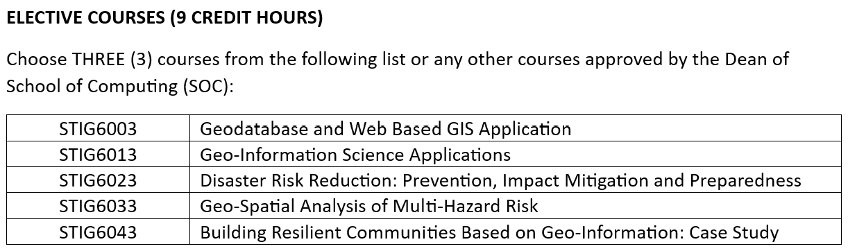
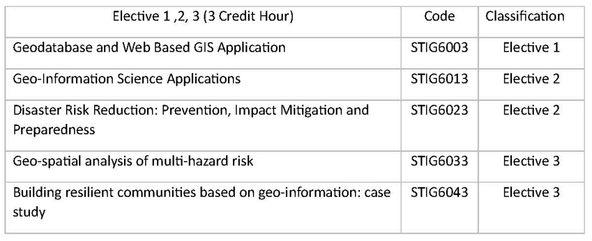
Elective Subject
- STIG 6003 Geodatabase and Web-Based GIS Application
This course describes the state-of-the-art knowledge on the widely applied GIS software such as ArcGIS and QGIS. In addition, this course also provides basic knowledge on the development and management of GIS website and database. - STIG 6013 Geo-Information Science Applications
This course discusses the application of the latest geoinformation science to the solution of complex issues across multidisciplinary of geophysical fields and societal needs for disaster risk reduction. - STIG 6023 Disaster Risk Reduction: Prevention, Impact Mitigation and Preparedness
This course provides knowledge about disaster management including disaster management cycle, policy and mechanism of disaster management, types of disaster, risk, hazard and vulnerability, management and reduction of disaster risk and post-disaster rehabilitation. - STIG 6033 Geospatial Analysis of Multi-Hazard Risk
The course begins by reviewing key concepts relevant for geospatial analysis of risk and vulnerability such as the definitions of these terms and practical issues such as geographic scale and the modifiable areal and temporal unit problems. Then, we will investigate how different types of hazards are represented spatially and how these differences make multi-hazard mapping and analysis challenging. We will then discuss the advantages and pitfalls of using casualty and economic loss datasets, before introducing students to the wide array of socioeconomic datasets frequently used in social vulnerability analyses. Students will learn several different approaches and methodologies for social vulnerability mapping and analysis and will learn how physical (risk) and social vulnerability analyses can be integrated into a single quantitative assessment. Students will also be exposed to participatory mapping approaches for risk and vulnerability. - STIG 6043 Building Resilient Communities Based on Geo-Information: Case Study
This course introduces students to the origins, concepts, and building Disaster Resilient communities through case studies from both developing and developed countries. real cases were to help students develop problem-solving skills in practical situations. This course also discusses importance of improving local communities’ resilience to natural hazards through the use of geoinformation approaches in the organization and management of natural disaster.
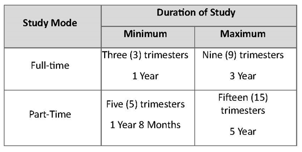
Full Time Programme Structure
Part Time Programme Structure
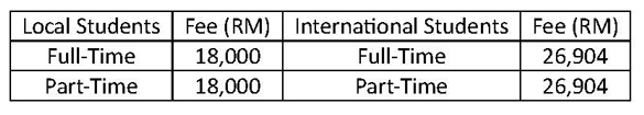
* The table shows the tuition fees for the MASTER OF SCIENCE (GEOINFORMATICS FOR DISASTER RISK REDUCTION). Other fees such as registration, accommodation and services, as well as international student’s bond, are not included here.
The university may revise the tuition fees from time to time. For updated information, please visit POSTGRADUATE STUDENT FEE